
USE CASE
Keeping stakeholders in the loop and on-board during highway redevelopment projects
The challenge
Redeveloping a lengthy section of any busy freeway is bound to cause disruptions for nearby residents and businesses. This community involvement team’s objectives were to minimize unexpected disruptions, maintain accurate, accessible records of their extensive stakeholder engagements, and communicate their progress to the state Department of Transportation (DOT) over the course of the project.
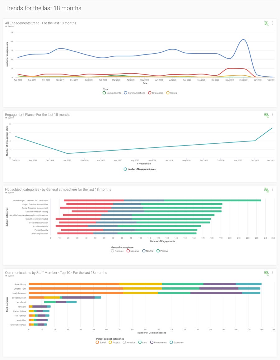
We’re now able to hold public involvement up to clear metrics. Instead of just reporting anecdotal success rates, we can easily present decision makers with clear figures backed with detailed records.
THE SOLUTION
Borealis Stakeholder Engagement Software
The team found that Borealis would not only meet their needs, it also includes features that they weren’t actively seeking, but that help them work more efficiently and effectively.
The ‘engagement plan’ tool allows them to design specific plans to work with different stakeholder groups, like businesses that will experience early and slightly higher impacts from the project. These plans allow the team to manage community outreach strategically and without overlooking anything.
Borealis also helps with an important step that isn’t necessarily obvious in most public involvement projects: translating outreach goals and strategies into concrete activities and tasks.
Each engagement plan is linked to its relevant stakeholders within the database the team imported into Borealis. The team member in charge of staffing simply assigns a list of stakeholders to each outreach agent for the month. Each stakeholder who needs to be contacted is considered a task in the plan.
The community involvement team is making use of the various tools and features in Borealis software to hit each of their established metrics and report progress to the DOT.
Recording stakeholder engagement
As agents work their way through their list, they enter all
relevant information into Borealis, such as which stakeholder they contacted, their understanding and opinion of the project,
etc. At the end of each call, stakeholders are given a link to a website with additional project information as well as contact numbers for voicing their concerns. All these details are saved in each stakeholder’s record. At the end of each month, the team sends an auto-generated report to the DOT showing their progress and success rate, demonstrating that it’s meeting the established metrics.
Everything in Borealis is very customizable – reports, dashboard, lists. We even created categories for individuals and organizations to better understand people’s relationships and affiliations, and an auto-generated error report to see if stakeholders haven’t been assigned a category.

Keeping stakeholder data clean
Users can refer to the data dictionary in Borealis to see the meaning of categories to ensure they’re assigning them correctly. For example, should a church that’s leasing some of the land it’s on to an organization be categorized as a place of worship or a business? The dictionary lets the team capture those nuances to keep data accurate.
Stakeholders often wear multiple hats. A stakeholder might sit on the council of one of the cities the project goes through, but also own a business near the laydown yard. With Borealis, we can accurately represent both “lives” in the database.
Borealis is much more feature rich than other platforms, but the graphics and interface are really user friendly. It’s powerful, but not intimidating. The customer service and training are excellent. If you have a question, you can always get ahold of someone.
Multiple access rights
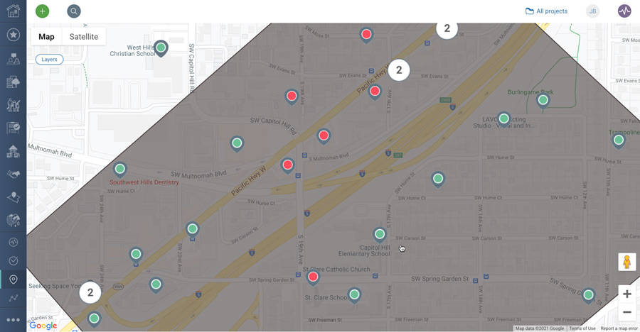
Mapping stakeholders and grievances
The team uses the GIS mapping feature in Borealis to see where stakeholders are geographically located in relation to the project. They can click on maps to drill down into the stakeholder’s entire record and engagement history. Inversely, they can map reports to put information in geographical perspective.
This visualization helps us understand the context in which a stakeholder is experiencing the project. It makes stakeholder concerns more real.
Once construction gets underway, the team will continue to use Borealis to document all communications and grievances and manage follow-ups. Instead of the usual hit-or-miss approach, the team will be able to see the exact status of a complaint or resolution.
If the dashboards show a concentration of grievances for a particular intersection, the team can communicate with the contractor and provide detailed information from the map to ensure it takes the necessary mitigation steps, as required under its contract.